Light snow is expected Tuesday night into Wednesday morning, with a coating to 1 inch of snow possible in most places, especially south of Interstate 78.
Localized amounts over 1 inch are possible, with the greatest chances in southern New Jersey, according to the National Weather Service forecast.
“A couple opportunities for light snow to occur across the region this week,” the weather service said early Monday. “The first coming Tuesday night and the second coming on Friday.”
For areas north of Interstate 78, perhaps some flurries are expected but no accumulations.
Snow will end by Wednesday morning with minimal impacts expected.
Another chance for light snow arrives Friday and possibly into Friday night as a strong clipper system passes through the region ahead of an Arctic front.
The weather service said it’s “too early for any specifics on this system, but a period of light snow and/or snow squalls appear to be on the table.”
More Arctic blasts ahead
A cold weather advisory remains in effect through 10 a.m. Monday for central and most of southern New Jersey, as lows between 5 and 15 degrees combined with steady winds will produce wind chills below zero for most of the region.
Outside of southeast New Jersey, wind chills region-wide will hover between zero and 5 below zero.
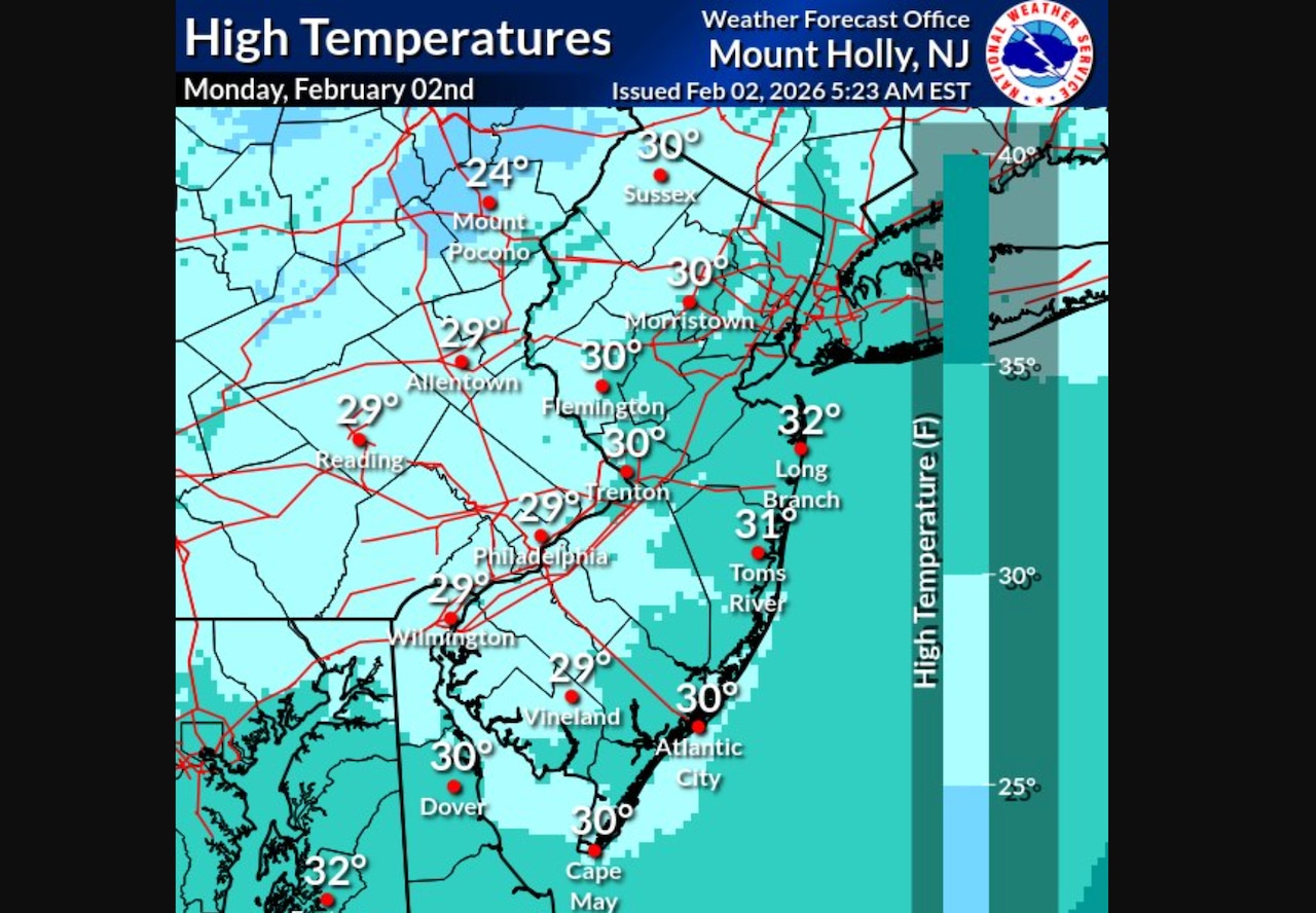
Temperatures on Monday will climb into the upper 20s and low 30s.
“Wall to wall sunshine is in forecast today for our area, where for many, this will be the warmest day since January 23rd,” the weather service said.
Widespread minor coastal flooding is expected Monday morning along the Jersey Shore.
A coastal flood advisory remains in effect from 7 a.m. to 1 p.m. Monday from Ocean County to Cape May.
Spotty minor flooding may also occur in Monmouth and Middlesex counties and along the Delaware Bay during Monday’s high tide.
Tuesday will be the best chance for parts of New Jersey to see above freezing temperatures with mid-to-upper 30s predicted for southern counties and upper 20s to low 30s in northern counties.
Temperatures will remain below normal throughout the rest of week, with highs in the low 20s to low 30s Wednesday through Friday.
Lows will be in the single digits and teens this week.
Highs next weekend will be in the teens and 20s, with lows ranging from single digits to as low as 5 below zero.
Wind chills will return to dangerously cold levels over the weekend.
Current weather radar